Lesson 6 – Techniques used for assessing impacts in EIA
Welcome to the e-learning lesson on the methods and techniques used for assessing impacts in Environmental Impact Assessment (EIA). In this course, we will discuss the various methods and techniques that are used to evaluate the impacts of proposed projects on the environment.
When assessing the impacts of a project, several factors will influence the approach adopted for the assessment of impacts and impact interactions. The method for evaluating the impact’s significance should be practical and suitable for the project, considering the available data, time, and financial resources.
The key points that should be considered when choosing the methods include the nature of the impacts, the availability and quality of data, and the availability of resources (time, finance, and staff). To ensure that various stages of the EIA process are carried out comprehensively and systematically, numerous methods have been developed over the years.
The most frequently used EIA methods and techniques include checklists, expert opinions, mass balances, matrices, and interaction diagrams, as well as qualitative models.
Checklists provide prescribed lists of environmental parameters that are to be checked for possible impacts of the proposed project. While checklists ensure that all likely events resulting from a project are considered, they are limited in discovering interdependencies or synergisms between interacting environmental components, nor are they able to describe variations of environmental conditions.
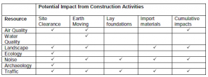
Example of a simple checklist
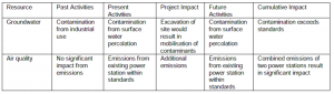
Example of the descriptive checklist
Expert opinions and perspectives from recognized experts in relevant fields are used in an attempt to resolve complex situations in a relatively short period of time. Consultations with the aid of questionnaires or workshops may be used.
Mass balance calculations refer to the analysis of existing situations and conditions with those that may result from proposed actions. They are mostly used in the context of air and water emissions as well as solid and hazardous wastes.
Matrices and interaction diagrams (networks) are used for cross-referencing a list of actions with environmental impact parameters. In this context, activities associated with various phases of a project or strategic action can be listed along one axis, with environmental components listed on the other. The simplest matrices indicate only the occurrence of an impact without any references to magnitude or significance. In more sophisticated matrices, the quantitative estimates of an impact magnitude and significance can be combined with a weighting scheme, leading to an ‘impact score’. The using of matrices provides a visual description of the relationship between two sets of the proposal being assessed, an identification of the impacts of different phases of a project, and an identification of the separate site-specific impacts affecting a region as a whole.
Networks are used to identify the structure, key elements, and interactions in a given system, using decision flowcharts and loop analysis. A network diagram visually describes the cause-effect links. The relative dependence of one factor on the condition of another one may be indicated by various arrow widths and heights. Negative and positive feedback loops can also be identified if the nature of the interrelationship is indicated.
Overlay mapping and Geographical Information Systems (GIS) are methods for identifying the spatial distribution of impacts, mainly physical ones, and can assist in identifying where cumulative impacts and their interactions may occur as a result of a project. Both methods involve the preparation of maps or layers of information which are then superimposed on one another. This can provide a composite picture of the baseline environment, identifying the sensitive areas or resources; showing the influences of past, present, and future activities on a project or receiving environment; and identifying where several impacts can cumulatively affect one particular receptor.
When considering the cumulative impacts from different projects, the baseline conditions should be mapped as the first. Information on other projects, such as their location and distribution of impacts if known, which may affect the resources should also be mapped. The maps showing the areas of influence of the other actions should be overlain on the map of the project and particular resource, for example, a river.